![](/images/other/stat-length.png)
![Trail Mountain bike Autrans-Méaudre en Vercors - Zevtt - Autrans-Villard de Lans - Photo](https://media.geolcdn.com/t/1900/400/ext.pjpeg?maxdim=2&url=https%3A%2F%2Fstatic1.geolcdn.com%2Fsiteimages%2Fupload%2Ffiles%2F1524743154velo.jpg)
Zevtt - Autrans-Villard de Lans
kipoura
User
![Length](/images/other/stat-length.png)
Length
44 km
![Max alt](https://static1.geolcdn.com/siteimages/upload/files/1508320355ic_sort_altitude_max_24dp.png)
Max alt
1667 m
![Uphill gradient](https://static1.geolcdn.com/siteimages/upload/files/1508320355ic_sort_den_pos_24dp.png)
Uphill gradient
1864 m
![Km-Effort](/images/other/stat-length.png)
Km-Effort
69 km
![Min alt](https://static1.geolcdn.com/siteimages/upload/files/1508320355ic_sort_altitude_min_24dp.png)
Min alt
883 m
![Downhill gradient](https://static1.geolcdn.com/siteimages/upload/files/1508320355ic_sort_den_neg_24dp.png)
Downhill gradient
1657 m
![Boucle](https://static1.geolcdn.com/siteimages/upload/files/16400158638029165_repeat_loop_refresh_sync_direction_icon.png)
Boucle
No
Creation date :
2019-05-03 17:11:31.271
Updated on :
2019-05-03 17:11:31.404
![Mountain bike](https://static1.geolcdn.com/sitytour/trail-icons/202.png)
6h00
Difficulty : Very difficult
![Scan this QR Code to open this trail in the SityTrail application](https://capi.geolives.com/qq0zvz2zws4bq2lad0pu/sitytour/trails/112962/qr.png?size=200)
FREE GPS app for hiking
About
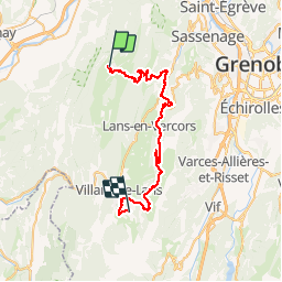
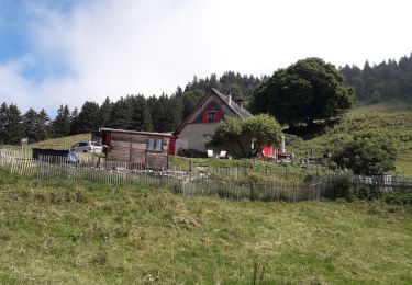
Trail Mountain bike of 44 km to be discovered at Auvergne-Rhône-Alpes, Isère, Autrans-Méaudre en Vercors. This trail is proposed by kipoura.
Description
Deuxième journée de la boucle VTT retour vers Villard de Lans. Attention première partie très harde .... portage sur les premiers kilomètres .... http://zevtt.free.fr
Positioning
Country:
France
Region :
Auvergne-Rhône-Alpes
Department/Province :
Isère
Municipality :
Autrans-Méaudre en Vercors
Location:
Autrans
Start:(Dec)
Start:(UTM)
699513 ; 5006031 (31T) N.
Comments
Trails nearby
![Trail Snowshoes Autrans-Méaudre en Vercors - Autrans: Gève - Bec de l'Orient - Photo](https://media.geolcdn.com/t/375/260/4e878d82-c145-4502-8e75-629fc9885006.jpg&format=jpg&maxdim=2)
![Snowshoes Snowshoes](https://static1.geolcdn.com/sitytour/trail-icons/504.png)
Autrans: Gève - Bec de l'Orient
Snowshoes
(3)
Autrans-Méaudre en Vercors,
Auvergne-Rhône-Alpes,
Isère,
France
![](/images/other/stat-length.png)
8.7 km | 12.9 km-effort
2h 46min
![](https://static1.geolcdn.com/siteimages/upload/files/16400158638029165_repeat_loop_refresh_sync_direction_icon.png)
Yes
![Trail Snowshoes Lans-en-Vercors - Charande, La Molière par les Aigaux - Photo](https://media.geolcdn.com/t/375/260/ext.jpg?maxdim=2&url=https%3A%2F%2Fservices.sitytrail.com%2FGeolivesWS%2FDownloadMedia.ashx%3FTrailID%3D518560%26Media%3Dfix__20160128112605.jpg)
![Snowshoes Snowshoes](https://static1.geolcdn.com/sitytour/trail-icons/504.png)
Charande, La Molière par les Aigaux
Snowshoes
Medium
(1)
Lans-en-Vercors,
Auvergne-Rhône-Alpes,
Isère,
France
![](/images/other/stat-length.png)
11.4 km | 18.8 km-effort
4h 30min
![](https://static1.geolcdn.com/siteimages/upload/files/16400158638029165_repeat_loop_refresh_sync_direction_icon.png)
Yes
![Trail Walking Autrans-Méaudre en Vercors - Autrans : Pas de l'Ours - Photo](https://media.geolcdn.com/t/375/260/ext.jpg?maxdim=2&url=https%3A%2F%2Fservices.sitytrail.com%2FGeolivesWS%2FDownloadMedia.ashx%3FTrailID%3D419322%26Media%3D20150509154225.jpg)
![Walking Walking](https://static1.geolcdn.com/sitytour/trail-icons/101.png)
Autrans : Pas de l'Ours
Walking
Difficult
(3)
Autrans-Méaudre en Vercors,
Auvergne-Rhône-Alpes,
Isère,
France
![](/images/other/stat-length.png)
11.6 km | 20 km-effort
4h 15min
![](https://static1.geolcdn.com/siteimages/upload/files/16400158638029165_repeat_loop_refresh_sync_direction_icon.png)
Yes
![Trail Walking Engins - La Molière - Vercors - Photo](https://media.geolcdn.com/t/375/260/ext.jpg?maxdim=2&url=https%3A%2F%2Fservices.sitytrail.com%2FGeolivesWS%2FDownloadMedia.ashx%3FTrailID%3D103760%26Media%3D6503_1.jpg)
![Walking Walking](https://static1.geolcdn.com/sitytour/trail-icons/101.png)
La Molière - Vercors
Walking
Easy
(3)
Engins,
Auvergne-Rhône-Alpes,
Isère,
France
![](/images/other/stat-length.png)
6.8 km | 9.6 km-effort
2h 0min
![](https://static1.geolcdn.com/siteimages/upload/files/16400158638029165_repeat_loop_refresh_sync_direction_icon.png)
Yes
![Trail Walking Autrans-Méaudre en Vercors - Traversée des Rochers de la Clé, Bec de l'Orient - Photo](https://media.geolcdn.com/t/375/260/ext.jpg?maxdim=2&url=https%3A%2F%2Fservices.sitytrail.com%2FGeolivesWS%2FDownloadMedia.ashx%3FTrailID%3D103329%26Media%3D5325_1.jpg)
![Walking Walking](https://static1.geolcdn.com/sitytour/trail-icons/101.png)
Traversée des Rochers de la Clé, Bec de l'Orient
Walking
Easy
(1)
Autrans-Méaudre en Vercors,
Auvergne-Rhône-Alpes,
Isère,
France
![](/images/other/stat-length.png)
9.4 km | 14.3 km-effort
3h 15min
![](https://static1.geolcdn.com/siteimages/upload/files/16400158638029165_repeat_loop_refresh_sync_direction_icon.png)
Yes
![Mountain bike Mountain bike](https://static1.geolcdn.com/sitytour/trail-icons/202.png)
autrans 10 2
Mountain bike
Medium
Autrans-Méaudre en Vercors,
Auvergne-Rhône-Alpes,
Isère,
France
![](/images/other/stat-length.png)
18.5 km | 25 km-effort
1h 43min
![](https://static1.geolcdn.com/siteimages/upload/files/16400158638029165_repeat_loop_refresh_sync_direction_icon.png)
Yes
![Mountain bike Mountain bike](https://static1.geolcdn.com/sitytour/trail-icons/202.png)
activity_9138581037
Mountain bike
Medium
Autrans-Méaudre en Vercors,
Auvergne-Rhône-Alpes,
Isère,
France
![](/images/other/stat-length.png)
16.9 km | 22 km-effort
1h 32min
![](https://static1.geolcdn.com/siteimages/upload/files/16400158638029165_repeat_loop_refresh_sync_direction_icon.png)
Yes
![Trail Walking Autrans-Méaudre en Vercors - 38 au dessus d Autrans ..cascade - Photo](https://media.geolcdn.com/t/375/260/d94ffa49-7c7e-4aff-a40e-79ece6fde182.jpg&format=jpg&maxdim=2)
![Walking Walking](https://static1.geolcdn.com/sitytour/trail-icons/101.png)
38 au dessus d Autrans ..cascade
Walking
Medium
Autrans-Méaudre en Vercors,
Auvergne-Rhône-Alpes,
Isère,
France
![](/images/other/stat-length.png)
8.2 km | 12.2 km-effort
2h 29min
![](https://static1.geolcdn.com/siteimages/upload/files/16400158638029165_repeat_loop_refresh_sync_direction_icon.png)
No
![Trail Walking Autrans-Méaudre en Vercors - Autrans - la Molière - Pas du Tracollet -,les Feneys - Photo](https://media.geolcdn.com/t/375/260/0dfbc41c-b9c0-4c58-b481-ede123a85e8c.jpg&format=jpg&maxdim=2)
![Walking Walking](https://static1.geolcdn.com/sitytour/trail-icons/101.png)
Autrans - la Molière - Pas du Tracollet -,les Feneys
Walking
Medium
Autrans-Méaudre en Vercors,
Auvergne-Rhône-Alpes,
Isère,
France
![](/images/other/stat-length.png)
16.3 km | 27 km-effort
5h 7min
![](https://static1.geolcdn.com/siteimages/upload/files/16400158638029165_repeat_loop_refresh_sync_direction_icon.png)
No